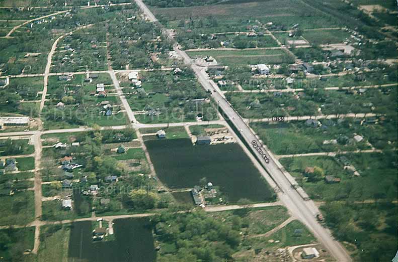
Here is an awesome aerial shot of Lisle sent in by Gary Klima.
If you stare at it long enough, a 3-D image of Bozo will appear. (Okay, just kidding...) What a great find this shot is!

Gary wrote:
Attached is a picture, (circa 1957-1960), which displays an aerial view of Ogden Avenue. To the North is downtown Lisle and Main Street. As you can see, this is the old Ogden cement overpass spanning RT 53, before the, "Modernization" period, and also notice that there is no access to RT 53. From the picture, you can see that there are still open areas, like Johannsen's farm. I think that's the Lisle Medical Center being built, (to the far left of the image). You'd probably know better, because that's your neck of the woods.
I'm still rummaging around some old slides...so stay tuned!!


Here is an aerial photo of Lisle in the late 40s to mid 50s. You can see Main Street,
the water tower and take a look at Main Street School! Great picture! Enjoy!

(Photo courtesy of
"owner of the Book Nook" John Reeder.)


No doubt one of my favorite photos of Lisle taken from the corner of Ogden & Winchester (looking east.) Click photo to see a larger view.


Here is a satellite photo of Lisle in 1983.
Click picture to see the larger view...Thank you
Bob Thompson!
 
Here is a satellite photo of Lisle in 2005.
Click picture to see the larger view... Thank you Google Earth!

* Plus... Can anyone get a copy of that large framed aerial photo
that is in the hallway at Lisle Jr. High?? (Formerly Lisle Sr. High)


We welcome your comments, stories or photos!

Contact us here.


BACK TO HOME PAGE